Vegetation map
Vegetation maps
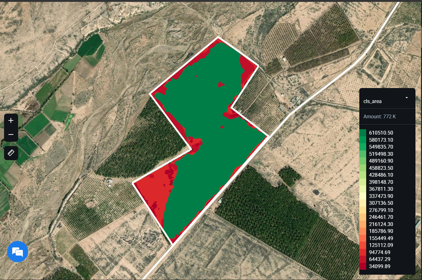
The vegetation map allows you to determine the areas within a field with variations in the state of vegetation (low to high) and adjust nitrogen fertilizer application, irrigation, and crop protection activities accordingly. We use a color grade scheme to visualize the variations in the state of crops across the field. The red color may indicate the poor state/health of the crops that are growing in this area of the field, while the green area usually indicates well-performing crops. The decision on the amount of N fertilizer, irrigation method, and proper crop protection also depends on the physical characteristics of a field, such as elevation differences and others.
After the maps are created, they are loaded into the equipment, and fertilizers are applied.
How to create vegetation maps?
- Usually, the NDVI index is used, which shows the vegetation in the field. It can be used to determine which parts of the growing field are better, which ones are worse. The amount of fertilizer that you will apply depends on this.
- The NDRE index can be used to map for mid- or late-season fertilization. It allows you to detect oppressed or aging vegetation, identify diseases, and help to optimize the timing of the harvest.
- The MSAVI index can be used to apply nitrogen fertilizers in the early stages when the soil is still partially bare.
- The ReCl is an index that displays chlorophyll in leaves. Allows you to identify areas of the field with yellowed and faded leaves that may require additional fertilization.
The user then applies different amounts of fertilizer in each zone on the map. There are different application strategies: for example, in areas with less vegetation, apply more fertilizers in order to level the soil composition over the field, or vice versa, apply fewer fertilizers if it is known that in the red zone, for example, there is unfavorable terrain. The choice of the method of application differs from field to field and is determined by the agronomists of the enterprise.
Further, the map can be downloaded in a SHP format and uploaded into the equipment. Soon we expect the release of an additional file format - ISO-XML, as well as the ability to calculate how much fertilizer and money you saved by opting for a differential application.
Create vegetation map for field
This endpoint is used to create a vegetation map for a field. You get a response with "request_url", which includes "field_id" and "zoning map ID".
HTTP Request
POST 'https://api-connect.eos.com/zoning/vegetation-map/' \
--header 'x-api-key: <api_key>' \
--header 'Content-Type: text/plain' \
--data-raw '{
    "field_id": "<field_id>",
    "vegetation_index":" index_name",
    "zone_quantity": "number",
    "min_zone_area": "number",
    "date_from": "date",
    "date_to": "date",
    "dataset_id": "satellite name",
    "need_answer": "false",
    "callback_url": "callback_url"
}'
Request Parameters
| Request Path Parameter | Description |
|---|---|
| api_key | (Required) Apikey retrieved from developer portal; |
| Request Body Parameter | Description |
|---|---|
| field_id | (required) The field identifier; You can see the example how to get field_id here |
| vegetation_index | (required) The vegetation indices Available value: NDVI, NDRE, MSAVI, RECI default value: NDVI |
| zone_quantity | (optional) The number of field zones that need to be divided field Available value by 2 to 7 Default value: 3; |
| min_zone_area | (optional) The minimum area of the zone in m2 Default value: 1000; |
| image_date | (optional) The date of the available image relative to the sensor (format YYYY-MM-DD) Default value: last available image; |
| dataset_id | (optional) Use for this parameter one value from the list of sensor names (it's the value of dataset_id from Supported Datasets) Default value: sentinel2; |
| need_answer | (optional) the need to notify about the completion of the formation of the vegetation map by email Available value: false - do not notify and true- notify Default value: false; |
Example: Create vegetation map for field
Step 1:
curl --location --request POST 'https://api-connect.eos.com/zoning/vegetation-map' \
--header 'Content-Type: application/json' \
--header 'x-api-key: <your_api_key>' \
--data '{
    "field_id":"9793351",
    "vegetation_index":"NDVI",
    "zone_quantity":"4",
    "min_zone_area":"1000",
    "dataset_id":"sentinel2",
    "need_answer":"true",
    "callback_url":"https://eods4xe0vk8nwi8.m.pipedream.net"
}'
Response:
{
    "status": "pending",
    "request_url": "https://api-connect.eos.com/api/cz/backend/api/zoning/9793351/3b958670-6354-450f-88b9-c48eeab6e7f1/?api_key="
}
Immediate results are not available as our system requires time to process (calculate) the information for your field.
The typical processing time ranges from 30 to 180 seconds.
Step 2
curl --location --request GET 'https://api-connect.eos.com/zoning/maps/9793351/3b958670-6354-450f-88b9-c48eeab6e7f1' \
--header 'x-api-key: <your_api_key>'
Response:
{
    "field_id": 9793351,
    "zmap_id": "3b958670-6354-450f-88b9-c48eeab6e7f1",
    "type_zmap": "vegetation",
    "vegetation_index": "NDVI",
    "date": "2024-01-08",
    "zones": [
        {
            "zone_1": {
                "zone_area": 14303.91,
                "zone_p": 18576.51,
                "fertilizer": 0,
                "geometry": {
                    "type": "MultiPolygon",
                    "coordinates": [
                        [[`array of coordinates`]]
                    ]
                },
                "kmean": [
                    0.09777519441266229
                ]
            }
        },
        {
            "zone_2": {
                "zone_area": 347772.85,
                "zone_p": 451653.05,
                "fertilizer": 0,
                "geometry": {
                    "type": "MultiPolygon",
                    "coordinates": [
                        [[`array of coordinates`]]
                    ]
                },
                "kmean": [
                    0.18228308580289643
                ]
            }
        },
        {
            "zone_3": {
                "zone_area": 358681.39,
                "zone_p": 465819.99,
                "fertilizer": 0,
                "geometry": {
                    "type": "MultiPolygon",
                    "coordinates": [
                        [[`array of coordinates`]]
                    ]
                },
                "kmean": [
                    0.21405458982280778
                ]
            }
        },
        {
            "zone_4": {
                "zone_area": 51941.98,
                "zone_p": 67457.12,
                "fertilizer": 0,
                "geometry": {
                    "type": "MultiPolygon",
                    "coordinates": [
                        [`array of coordinates`]
                    ]
                },
                "kmean": [
                    0.28425001577317754
                ]
            }
        }
    ],
    "total_fertilizer_consumption": 0,
    "image_link": "https://lvproc-res-eu.eos.com/1224889/9f40f17965bd019653e9fcba7c2972b22024010816291704731378/S2-13-R-EL-2024-1-5-0__NIR-RED___NIR_RED_.geojson"
}
For example, displaying shp file of zoning map at the Crop Monitoring platform:
Error codes:
Response - The field hasn't zones
Status 404 Not Found
{"field_id":"id",
 "message": "This field has no available zoning maps"
}
Response - if the user does not have access to the specified field
Status 404 Not Found
{"field_id":"id",
 "message": "The field is not available to you"
}