Zoning API
Zoning is an effective tool for carrying out the variable-rate application of seeds, fertilizers, differential irrigation, and differential crop rotation, as well as for determining optimal zones (areas) for precision soil sampling. Based on the in-zone data measured using a vegetation index, a map can be created on the platform and imported to the agriculture equipment. The equipment can then follow the map as a script, applying the precisely calculated amount of seeds and/or fertilizers to specific zones (areas) within a field. Variable-rate application of inputs and precision soil sampling are highly cost-effective since they allow you to allocate resources more rationally. VRA of inputs is also more sustainable as it can help prevent the overuse of nitrogen, phosphorus, and potassium fertilizers, as well as of crop protection substances.
How to create Vegetation Map
The vegetation map allows you to determine the areas within a field with variations in the state of vegetation (low to high) and adjust nitrogen fertilizer application, irrigation, and crop protection activities accordingly.
How to create Productivity Map
The productivity map is your guide to the variable-rate application of potassium (K) and phosphorus (P) fertilizers, differential sowing, and precision soil sampling.
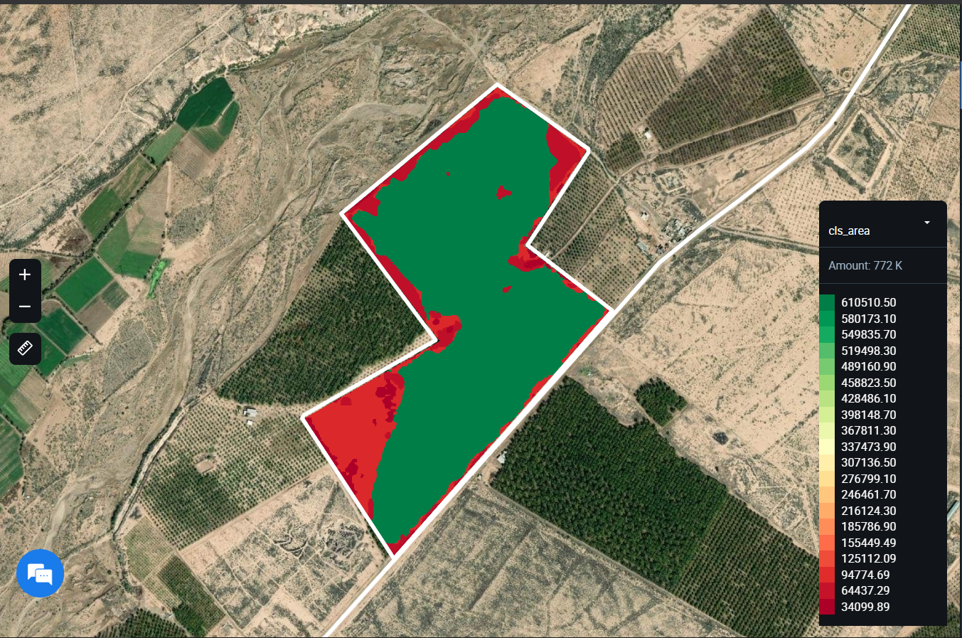
For example, displaying shp file of zoning map at the Crop Monitoring platform:
Get the list of zoning maps for field
This endpoint is used to obtain a list of ready zoning results (vegetation and productivity maps) for the field.
HTTP Request
GET 'https://api-connect.eos.com/api/zoning/<field_id>?api_key=your_api_key'
Request Parameters
| Request Path Parameter | Description |
|---|---|
| api_key | (Required) Apikey retrieved from developer portal; |
| field_id | (Required) The field identifier; You can see the example how to get field_id here |
HTTP Response
The field has one or more created zones
{"field_id":"id",
 "maps": {
   {"zmap_id":"id",
    "type_zmap":"type_zmap",
    "zmap_detail":
      { "vegetation_index":"vegetation_index_name",
        "zone_quantity":"quantity",
        "date": "Date"
      }
    },
    {..............},
    {|"zmap_id":"id",
     "type_zmap":"type_zmap",
     "zmap_detail":
       { "vegetation_index":"vegetation_index_name",
         "zone_quantity":"quantity",
         "date": "Date"
       }
     }
   }
}
Response parameters
| Parameter | Description |
|---|---|
| field_id | The field identifier; You can see the example how to get field_id here |
| maps | The list of available zoning maps; |
| zmap_id | The zoning map ID is assigned upon creation and is unique within the system; |
| type_zmap | The type of map (vegetation or productivity); |
| zmap_detail.vegetation_index | The type of vegetation index; available values: NDVI, NDRE, MSAVI, RECI, NDMI |
| zmap_detail.zone_quantity | The number of zones created for the field; |
| zmap_detail.date | The date of creation of vegetation map or a period for a productivity map; |
Response - The field hasn't zones
Status 404 Not Found
{"field_id":"id",
 "message": "This field has no available zoning maps"
}
Response - if the user does not have access to the specified field
Status 404 Not Found
{"field_id":"id",
 "message": "The field is not available to you"
}
Examples
Request
curl --location --request GET 'https://api-connect.eos.com/api/cz/backend/api/zoning/6921647?api_key=<your_api_key>'
Response
{
    "maps": [
        {
            "zmap_id": "96bcf4ea-7126-4a7c-b444-32d20ba5638c",
            "type_zmap": "productivity",
            "zmap_detail": {
                "vegetation_index": "NDVI",
                "zone_quantity": 5,
                "date": {
                    "start": "2020-01-01",
                    "end": "2020-09-08"
                }
            }
        },
        {
            "zmap_id": "f3c24f03-e8c7-4862-a550-a42559c0b86c",
            "type_zmap": "vegetation",
            "zmap_detail": {
                "vegetation_index": "NDVI",
                "zone_quantity": 3,
                "date": "2020-09-04"
            }
        }
    ],
    "field_id": "6921647"
}
Get zoning map for field
This endpoint is used for getting zone information with set values in fertilization units for the field. The average processing time is 30-300 seconds.
HTTP Request
GET 'https://api-connect.eos.com/api/zoning/<field_id>/<zmap_id>?api_key=your_api_key'
Request Parameters
| Request Path Parameter | Description |
|---|---|
| api_key | (Required) Apikey retrieved from developer portal; |
| field_id | (Required) The field identifier; |
| zmap_id | (Required) The zoning map identifier; |
HTTP Response
The field has one or more created zones
status 200

{ "field_id":"id",
"zmap_id":"id",
"type_zmap":"type_zmap",
"vegetation_index":"vegetation_index_name",
"date": "Date",
"zones":
  {
    "zone_1":
      { "zone_area":"numeric",
        "zone_p":"numeric",
        "fertilizer":"numeric",
        "geometry": {
           "type": "MultiPolygon",
           "coordinates": [ [ [lat, lon],[........], [lat, lon]  ] ] }
     },
     {..............},
     "zone_X":
      { "zone_area":"numeric",
        "zone_p":"numeric",
        "fertilizer":"numeric",
        "geometry": {
           "type": "MultiPolygon",
           "coordinates": [ [ [lat, lon],[........], [lat, lon] ] ] }
      },
"total_fertilizer_consumption":"numeric",
"image_link":"link"
}
Response parameters
| Parameter | Description |
|---|---|
| field_id | The field identifier;You can see the example how to get field_id here |
| zmap_id | The zoning map ID is assigned upon creation and is unique within the system; |
| type_zmap | The type of map (vegetation or productivity); |
| vegetation_index | The type of vegetation index; |
| date | The date of creation of vegetation map or a period for a productivity map; |
| zones | The list of zones the maximum value for the vegetation map is 7, and for productivity - 5; |
| zones.zone_area | The area of the zone, depending on the location (or hectare or acre); |
| zones.zone_p | in percent area of the zone from the total area of the field; |
| zones.fertilizer | The value for the spread rate in the zone; |
| zones.geometry | The GeoJSON representation of a geometry describing the AOI; |
| total_fertilizer_consumption | The total value for fertilization in units; |
| image_link | The link to download the image of the containing zone; |
Response - The field hasn't zones
Status 404 Not Found
{"field_id":"id",
 "message": "This field has no available zoning maps"
}
Response - if the user does not have access to the specified field
Status 404 Not Found
{"field_id":"id",
 "message": "The field is not available to you"
}
Examples
Request
curl --location --request GET 'https://api-connect.eos.com/api/cz/backend/api/zoning/6921647?api_key=<your_api_key>'
Response
{
"field_id": 6921647,
"zmap_id": "f3c24f03-e8c7-4862-a550-a42559c0b86c",
"type_zmap": "vegetation",
"vegetation_index": "NDVI",
"date": "2020-09-08",
"zones": [
{
"zone_1": {
"zone_p": 12302.26,
"fertilizer": 0,
"zone_area": 1304.04,
"geometry": {
"coordinates": [
[
[
-122.07432746887204,
39.51278188465406
],
[
-122.07432746887204,
39.51119266116078
],
[
-122.07424163818355,
39.51119266116078
],
[
-122.07424163818355,
39.51278188465406
],
[
-122.07432746887204,
39.51278188465406
]
]
],
"type": "MultiPolygon"
}
}
},
{
"zone_2": {
"zone_p": 353177.74,
"fertilizer": 0,
"zone_area": 37436.84,
"geometry": {
"coordinates": [
[
[
-122.07424163818355,
39.51278188465406
],
[
-122.07424163818355,
39.512649450751425
],
[
-122.07381248474118,
39.512649450751425
],
[
-122.07381248474118,
39.51251701659635
],
[
-122.07389831542966,
39.51251701659635
],
[
-122.07406997680663,
39.51251701659635
],
[
-122.07406997680663,
39.5119210597744
],
[
-122.07243919372556,
39.5119210597744
],
[
-122.07243919372556,
39.512119712616396
],
[
-122.07218170166011,
39.512119712616396
],
[
-122.07218170166011,
39.5119210597744
],
[
-122.07175254821775,
39.5119210597744
],
[
-122.07175254821775,
39.512119712616396
],
[
-122.0714950561523,
39.512119712616396
],
[
-122.0714950561523,
39.5119210597744
],
[
-122.07098007202147,
39.5119210597744
],
[
-122.07098007202147,
39.51172240636439
],
[
-122.07106590270993,
39.51172240636439
],
[
-122.07123756408689,
39.51172240636439
],
[
-122.07123756408689,
39.51139131608547
],
[
-122.07132339477536,
39.51139131608547
],
[
-122.0714950561523,
39.51139131608547
],
[
-122.0714950561523,
39.51119266116078
],
[
-122.07106590270993,
39.51119266116078
],
[
-122.07106590270993,
39.51112644272632
],
[
-122.070894241333,
39.51112644272632
],
[
-122.07080841064449,
39.51112644272632
],
[
-122.07080841064449,
39.51158997044216
],
[
-122.07063674926755,
39.51158997044216
],
[
-122.07055091857907,
39.51158997044216
],
[
-122.07055091857907,
39.51172240636439
],
[
-122.07080841064449,
39.51172240636439
],
[
-122.07080841064449,
39.512119712616396
],
[
-122.07063674926755,
39.512119712616396
],
[
-122.07055091857907,
39.512119712616396
],
[
-122.07055091857907,
39.51245079942414
],
[
-122.07098007202147,
39.51245079942414
],
[
-122.07098007202147,
39.512649450751425
],
[
-122.06849098205564,
39.512649450751425
],
[
-122.06849098205564,
39.51245079942414
],
[
-122.06857681274411,
39.51245079942414
],
[
-122.06866264343259,
39.51245079942414
],
[
-122.06866264343259,
39.51225214752883
],
[
-122.06874847412107,
39.51225214752883
],
[
-122.06892013549803,
39.51225214752883
],
[
-122.06892013549803,
39.512119712616396
],
[
-122.06866264343259,
39.512119712616396
],
[
-122.06866264343259,
39.51205349506551
],
[
-122.06806182861325,
39.51205349506551
],
[
-122.06797599792478,
39.51205349506551
],
[
-122.06797599792478,
39.512649450751425
],
[
-122.0678901672363,
39.512649450751425
],
[
-122.06780433654782,
39.512649450751425
],
[
-122.06780433654782,
39.51278188465406
],
[
-122.07424163818355,
39.51278188465406
]
]
],
"type": "MultiPolygon"
}
}
},
{
"zone_3": {
"zone_p": 608449.91,
"fertilizer": 0,
"zone_area": 64495.69,
"geometry": {
"coordinates": [
[
[
-122.07098007202147,
39.512649450751425
],
[
-122.07098007202147,
39.51245079942414
],
[
-122.07055091857907,
39.51245079942414
],
[
-122.07055091857907,
39.512119712616396
],
[
-122.07063674926755,
39.512119712616396
],
[
-122.07080841064449,
39.512119712616396
],
[
-122.07080841064449,
39.51172240636439
],
[
-122.07055091857907,
39.51172240636439
],
[
-122.07055091857907,
39.51158997044216
],
[
-122.07063674926755,
39.51158997044216
],
[
-122.07080841064449,
39.51158997044216
],
[
-122.07080841064449,
39.51112644272632
],
[
-122.0678901672363,
39.51112644272632
],
[
-122.06780433654782,
39.51112644272632
],
[
-122.06780433654782,
39.512649450751425
],
[
-122.06797599792478,
39.512649450751425
],
[
-122.06797599792478,
39.51205349506551
],
[
-122.06806182861325,
39.51205349506551
],
[
-122.06866264343259,
39.51205349506551
],
[
-122.06866264343259,
39.512119712616396
],
[
-122.06892013549803,
39.512119712616396
],
[
-122.06892013549803,
39.51225214752883
],
[
-122.06874847412107,
39.51225214752883
],
[
-122.06866264343259,
39.51225214752883
],
[
-122.06866264343259,
39.51245079942414
],
[
-122.06857681274411,
39.51245079942414
],
[
-122.06849098205564,
39.51245079942414
],
[
-122.06849098205564,
39.512649450751425
],
[
-122.07098007202147,
39.512649450751425
]
],
[
[
-122.07424163818355,
39.512649450751425
],
[
-122.07424163818355,
39.51119266116078
],
[
-122.07432746887204,
39.51119266116078
],
[
-122.07432746887204,
39.51112644272632
],
[
-122.07115173339841,
39.51112644272632
],
[
-122.07106590270993,
39.51112644272632
],
[
-122.07106590270993,
39.51119266116078
],
[
-122.0714950561523,
39.51119266116078
],
[
-122.0714950561523,
39.51139131608547
],
[
-122.07132339477536,
39.51139131608547
],
[
-122.07123756408689,
39.51139131608547
],
[
-122.07123756408689,
39.51172240636439
],
[
-122.07106590270993,
39.51172240636439
],
[
-122.07098007202147,
39.51172240636439
],
[
-122.07098007202147,
39.5119210597744
],
[
-122.0714950561523,
39.5119210597744
],
[
-122.0714950561523,
39.512119712616396
],
[
-122.07175254821775,
39.512119712616396
],
[
-122.07175254821775,
39.5119210597744
],
[
-122.07218170166011,
39.5119210597744
],
[
-122.07218170166011,
39.512119712616396
],
[
-122.07243919372556,
39.512119712616396
],
[
-122.07243919372556,
39.5119210597744
],
[
-122.07406997680663,
39.5119210597744
],
[
-122.07406997680663,
39.51251701659635
],
[
-122.07389831542966,
39.51251701659635
],
[
-122.07381248474118,
39.51251701659635
],
[
-122.07381248474118,
39.512649450751425
],
[
-122.07424163818355,
39.512649450751425
]
]
],
"type": "MultiPolygon"
}
}
}
],
"total_fertilizer_consumption": 0,
"image_link": "https://lvproc-res-eu.s3.amazonaws.com/305795/a23e8af72eead3b706809ad058c6c94a2020090803341599536056/S2L2A-10-S-EJ-2020-9-4-0__NIR-RED___NIR_RED_.geojson?X-Amz-Algorithm=AWS4-HMAC-SHA256&X-Amz-Credential=AKIAJ2SI55X7X6AVM6LA%2F20200908%2Feu-central-1%2Fs3%2Faws4_request&X-Amz-Date=20200908T033424Z&X-Amz-Expires=604800&X-Amz-SignedHeaders=host&X-Amz-Signature=8dae9098e9a180fdc96bab83e2cc25eed41f28ec48e98009535362f6c16f92a3"
}
Get shp-file for field
This endpoint is used for getting about the zone and the established rates of fertilization for the field in the form of an archive with data by analogy as implemented in Crop Monitoring (containing files dbf, prj, shp, shx)
HTTP Request
GET 'https://api-connect.eos.com/api/zoning/shp/<field_id>/<zmap_id>?api_key=your_api_key'
For example, displaying shp file of zoning map at the Crop Monitoring platform:
Request Parameters
| Request Path Parameter | Description |
|---|---|
| api_key | (Required) Apikey retrieved from developer portal; |
| field_id | (Required) The field identifier; You can see the example how to get field_id here |
| zmap_id | (Required) The zoning map identifier; |
HTTP Response
The field has one or more created zones
status 200

the process of download the archive file begins
Response parameters
| Parameter | Description |
|---|---|
| field_id | The field identifier; You can see the example how to get field_id here |
| zmap_id | The zoning map ID is assigned upon creation and is unique within the system; |
| type_zmap | The type of map (vegetation or productivity); |
| vegetation_index | The type of vegetation index; |
| date | The date of creation of vegetation map or a period for a productivity map; |
| zones | The list of zones the maximum value for the vegetation map is 7, and for productivity - 5; |
| zones.zone_area | The area of the zone, depending on the location (or hectare or acre); |
| zones.zone_p | in percent area of the zone from the total area of the field; |
| zones.fertilizer | The value for the spread rate in the zone; |
| zones.geometry | The GeoJSON representation of a geometry describing the AOI; |
| total_fertilizer_consumption | The total value for fertilization in units; |
| image_link | The link to download the image of the containing zone; |
Response - The field hasn't zones
Status 404 Not Found
{"field_id":"id",
 "message": "This field has no available zoning maps"
}
Response - if the user does not have access to the specified field
Status 404 Not Found
{"field_id":"id",
 "message": "The field is not available to you"
}
Examples
Request
curl --location --request GET 'https://api-connect.eos.com/api/cz/backend/api/zoning/shp/6921647/f3c24f03-e8c7-4862-a550-a42559c0b86c/?api_key=<your_api_key>'
Response
status 200
the process of download the archive file begins
Deleting zoning map for field
This endpoint is used for deleting one zone for the field.
HTTP Request
DELETE 'https://api-connect.eos.com/api/zoning/<field_id>/<zmap_id>?api_key=your_api_key'
Request Parameters
| Request Path Parameter | Description |
|---|---|
| api_key | (Required) Apikey retrieved from developer portal; |
| field_id | (Required) The field identifier; |
| zmap_id | (Required) The zoning map identifier; |
HTTP Response
The field has one or more created zones
status 204
Response - The field hasn't zones
Status 404 Not Found
{"field_id":"id",
 "message": "This field has no available zoning maps"
}
Response - if the user does not have access to the specified field
Status 404 Not Found
{"field_id":"id",
 "message": "The field is not available to you"
}
Examples
Request
curl --location --request DELETE 'https://api-connect.eos.com/api/cz/backend/api/zoning/6921647/96bcf4ea-7126-4a7c-b444-32d20ba5638c/?api_key=<your_api_key>'
Response
Status 204
Deleting all zoning maps for field
This endpoint is used for deleting all zone for the field.
HTTP Request
DELETE 'https://api-connect.eos.com/api/zoning/<field_id>/ALL?api_key=your_api_key'
Request Parameters
| Request Path Parameter | Description |
|---|---|
| api_key | (Required) Apikey retrieved from developer portal; |
| field_id | (Required) The field identifier; |
HTTP Response
The field has one or more created zones
status 204
Response - The field hasn't zones
Status 404 Not Found
{"field_id":"id",
 "message": "This field has no available zoning maps"
}
Response - if the user does not have access to the specified field
Status 404 Not Found
{"field_id":"id",
 "message": "The field is not available to you"
}
Examples
Request
curl --location --request DELETE 'https://api-connect.eos.com/api/cz/backend/api/zoning/6921647/ALL?api_key=<your_api_key>'
Response
Status 204