Single dataset search
Search API for a single dataset where the value of the dataset parameter is specified in the URL.
Get the list of scenes that cover users fields
HTTP Request
POST 'https://api-connect.eos.com/api/lms/search/v2/<dataset_id>?api_key=<your_api_key>' \
--data-raw '{
    "intersection_validation": true,
    "search": {
        "date": {"from":"date","to":"date"},
        "cloudCoverage":{"from": number,"to": number},
        "shapeRelation": "CONTAINS",
        "shape": {  "type": "Polygon",
                    "coordinates": [
                             [   [lon,lat],
                                 [lon,lat],
                                 .........,
                                 [lon,lat],
                                 [lon,lat],
                             ]
                         ]
                  }
       },
    "sort":{"date":"desc"},
    "fields": ["sceneID","cloudCoverage"],
    "limit": number,
    "page": number
}
Request Parameters
| Request Path Parameter | Description |
|---|---|
| api_key | (Required) Apikey retrieved from developer portal |
| dataset_id | (Required) One of the available dataset_id |
| Request Body Parameter | Description |
|---|---|
| search | (required) Request parameters. Search request can be a combination of filters for any of dataset’s fields except for tms and view_id. |
| search.date | (required) Range of the dates. There are different filters to apply: 1. match documents who’s field’s value is within the query’s range: {‘fieldName’: {‘from’: ‘val1’, ‘to’: ‘val2’}}; 2. match documents who’s field’s value is one of the query’s values: {‘fieldName’: [‘v0’, ‘v1’, ‘v2’]}; 3. match documents who’s field’s value matches the query exactly: {‘fieldName’: ‘value’}. Examples: 1. find all scenes acquired in 2016: ‘date’: {‘from’: ‘2016-01-01’, ‘to’: ‘2016-12-31’}; 2. find scenes acquired either on 1 August 2016, 1 September 2016, 1 October 2016: ‘date’: [‘2016-08-01’, ‘2016-09-01’, ‘2016-10-01’]; 3. find scenes acquired on 1 August 2016: ‘date’: ‘2016-08-01’Please note that for optimal service stability, it is recommended to search up to 365 days (1 year) as date range |
| search.cloudCoverage | (optional) Range of cloud cover percentages by scenes. |
| search.shape | (required) A GeoJSON representation of a geometry describing the AOI. Supported geometry types: "Polygon" and "Point" Please note: when you add coordinates in the first place - longitude and in the second - latitude. You can use these tools to check if the coordinates are valid https://geojson.io/, https://geojsonlint.com/. |
| search.shapeRelation | (optional - only used with shape) - relation between requested shape geometry and matching scenes. Valid values are: INTERSECTS (default) - the geometry in the request and the scene geometry intersect , CONTAINS - the scene geometry CONTAINS geometry in the request (100% coverage of the request geometry by the scene geometry), DISJOINT - the geometry in the request and the scene geometry do not intersect, WITHIN - the scene geometry inside the request geometry (100% coverage of the scene geometry by the request geometry). |
| sort | (optional) Sorting to perform. Can either be in the form fieldName:asc or fieldName:desc. Example: cloudCover: asc (sort results such that the least cloudy scenes come first). Default: date: desc (the newest scenes come first) |
| page | (optional) Number of page, used for pagination. Default: 1 |
| limit | (optional) Number of results per page. Default: 500 |
| intersection_validation | (optional) If true, enables additional validation for relation between shape and geometry of the scenes (false by default). Relation is determined by shapeRelation filter value. Note: Pagination and found scene counter are not fully supported in conjunction with this parameter. |
| fields | (optional) An array of the selective stored fields of the document to return for each hit, comma-delimited. More details about the available filter parameters Not specifying any value will cause all available fields to return. Example: [‘sceneId’, ‘cloudCover’] |
HTTP Response
{
    "results": [
        {
            "tms": "link",
            "sceneID": "scene’s identifier",
            "cloudCoverage": number,
            "view_id": "view’s identifier"
        },
        {....................},
        {
            "tms": "link",
            "sceneID": "scene’s identifier",
            "cloudCoverage": number,
            "view_id": "view’s identifier"
        }        ],
    "meta": {
        "found": number,
        "name": "satellite-meta-service",
        "page": number,
        "limit": number
    }
}
Response parameters
| Parameter | Description |
|---|---|
| tms | The link to tile map; |
| sceneID | The scene’s identifier; |
| cloudCoverage | Value of Cloud Coverage for the scene; |
| view_id | The view’s identifier; |
| found | Quantity of scene found; |
| page | Quantity of page with scenes; |
| limit | Quantity of scenes returned; |
| and other parameters | Other parameters are available if you change request conditions; |
Examples
Search scenes for Sentinel2
curl --location --request POST 'https://api-connect.eos.com/api/lms/search/v2/sentinel2' \
--header 'Content-Type: text/plain' \
--header 'x-api-key: <your_api_key>' \
--data '{
    "fields": [
              "sunElevation", "cloudCoverage", "sceneID", "date",
                "productID", "sensor", "dataCoveragePercentage"
            ],
    "limit": 500,
    "page": 1,
    "intersection_validation": true,
    "search": {
        "date": {"from": "2023-06-01","to": "2023-07-31"},
        "cloudCoverage": {"from": 0,"to": 90},
        "shapeRelation": "CONTAINS",
        "shape": {
                    "type": "Polygon",
                    "coordinates": [
                          [
                              [-86.86718,41.317464],
                              [-86.86718,41.331596],
                              [-86.862631,41.331596],
                              [-86.862631,41.317464],
                              [-86.86718,41.317464]
                            ]
                        ]
                  }
     },
    "sort":{"date":"desc"}
}'
Response to request for search scene for Sentinel2
{
    "meta": {
        "found": 17,
        "name": "satellite-meta-service",
        "page": 1,
        "limit": 2
    },
    "results": [
        {
            "date": "2023-07-31",
            "sunElevation": 62.7193936329362,
            "cloudCoverage": 2.0,
            "dataGeometry": {
                "coordinates": [
                    [
                        [
                            -87.00022782817362,
                            41.55183566226867
                        ],
                        [
                            -87.00022444079165,
                            40.56275892201299
                        ],
                        [
                            -85.70337428842777,
                            40.555482279926174
                        ],
                        [
                            -85.68381174363218,
                            41.544302667202295
                        ],
                        [
                            -87.00022782817362,
                            41.55183566226867
                        ]
                    ]
                ],
                "type": "Polygon",
                "crs": {
                    "type": "name",
                    "properties": {
                        "name": "urn:ogc:def:crs:EPSG:8.9:4326"
                    }
                }
            },
            "sceneID": "S2B_tile_20230731_16TEL_0",
            "dataCoveragePercentage": 100.0,
            "tms": "https://render.eosda.com/S2/16/T/EL/2023/7/31/0/{band}/{z}/{x}/{y}",
            "view_id": "S2/16/T/EL/2023/7/31/0"
        },
        {
            "date": "2023-07-29",
            "sunElevation": 64.2465407798637,
            "cloudCoverage": 75.7,
            "dataGeometry": {
                "coordinates": [
                    [
                        [
                            -87.00022782817362,
                            41.55183566226867
                        ],
                        [
                            -87.00022444380076,
                            40.5636598179917
                        ],
                        [
                            -86.40715370319707,
                            40.56231853513746
                        ],
                        [
                            -86.04684004963566,
                            41.54788519803006
                        ],
                        [
                            -87.00022782817362,
                            41.55183566226867
                        ]
                    ]
                ],
                "type": "Polygon",
                "crs": {
                    "type": "name",
                    "properties": {
                        "name": "urn:ogc:def:crs:EPSG:8.9:4326"
                    }
                }
            },
            "sceneID": "S2A_tile_20230729_16TEL_0",
            "dataCoveragePercentage": 59.01,
            "tms": "https://render.eosda.com/S2/16/T/EL/2023/7/29/0/{band}/{z}/{x}/{y}",
            "view_id": "S2/16/T/EL/2023/7/29/0"
        }
    ]
}
Search scenes for Landsat9
curl --location --request POST 'https://api-connect.eos.com/api/lms/search/v2/landsat9' \
--header 'Content-Type: text/plain' \
--header 'x-api-key: <your_api_key>' \
--data '{
    "fields": [
              "sunElevation", "cloudCoverage", "sceneID", "date","sensor", "dataCoveragePercentage"
            ],
    "limit": 500,
    "page": 1,
    "intersection_validation": true,
    "search": {
        "date": {"from": "2023-06-01","to": "2023-07-31"},
        "cloudCoverage": {"from": 0,"to": 90},
        "shapeRelation": "CONTAINS",
        "shape": {
                    "type": "Polygon",
                    "coordinates": [
                          [
                              [-86.86718,41.317464],
                              [-86.86718,41.331596],
                              [-86.862631,41.331596],
                              [-86.862631,41.317464],
                              [-86.86718,41.317464]
                            ]
                        ]
                  }
     },
    "sort":{"date":"desc"}
}'
Response to request for search scene for Landsat9
{
    "meta": {
        "found": 3,
        "name": "satellite-meta-service",
        "page": 1,
        "limit": 2
    },
    "results": [
        {
            "date": "2023-07-31",
            "sunElevation": 60.29310356,
            "awsPath": "collection02/level-1/standard/oli-tirs/2023/022/031/LC09_L1TP_022031_20230731_20230801_02_T1/",
            "cloudCoverage": 11.51,
            "sceneID": "LC09_L1TP_022031_20230731_20230801_02_T1",
            "dataGeometry": {
                "coordinates": [
                    [
                        [
                            -87.60622652147855,
                            42.80946719025564
                        ],
                        [
                            -88.14245077923233,
                            41.09475821555301
                        ],
                        [
                            -85.9859806995821,
                            40.693563919146705
                        ],
                        [
                            -85.39160776849965,
                            42.405878260618216
                        ],
                        [
                            -87.60622652147855,
                            42.80946719025564
                        ]
                    ]
                ],
                "type": "Polygon"
            },
            "sensor": "OLI_TIRS",
            "tms": "https://render.eosda.com/L9/LC09_L1TP_022031_20230731_20230801_02_T1/{band}/{z}/{x}/{y}",
            "view_id": "L9/LC09_L1TP_022031_20230731_20230801_02_T1",
            "thumbnail": "https://usgs-landsat.eos.com/collection02/level-1/standard/oli-tirs/2023/022/031/LC09_L1TP_022031_20230731_20230801_02_T1/LC09_L1TP_022031_20230731_20230801_02_T1_thumb_small.jpeg"
        },
        {
            "date": "2023-07-15",
            "sunElevation": 63.02642204,
            "awsPath": "collection02/level-1/standard/oli-tirs/2023/022/031/LC09_L1TP_022031_20230715_20230715_02_T1/",
            "cloudCoverage": 37.73,
            "sceneID": "LC09_L1TP_022031_20230715_20230715_02_T1",
            "dataGeometry": {
                "coordinates": [
                    [
                        [
                            -87.61870137725101,
                            42.80940046632809
                        ],
                        [
                            -88.15495108205951,
                            41.094633579197996
                        ],
                        [
                            -85.99841036071045,
                            40.69340217691492
                        ],
                        [
                            -85.40364750135215,
                            42.40550624442422
                        ],
                        [
                            -87.61870137725101,
                            42.80940046632809
                        ]
                    ]
                ],
                "type": "Polygon"
            },
            "sensor": "OLI_TIRS",
            "tms": "https://render.eosda.com/L9/LC09_L1TP_022031_20230715_20230715_02_T1/{band}/{z}/{x}/{y}",
            "view_id": "L9/LC09_L1TP_022031_20230715_20230715_02_T1",
            "thumbnail": "https://usgs-landsat.eos.com/collection02/level-1/standard/oli-tirs/2023/022/031/LC09_L1TP_022031_20230715_20230715_02_T1/LC09_L1TP_022031_20230715_20230715_02_T1_thumb_small.jpeg"
        }
    ]
}

Render example
After that you can render scenes you've get before in the Search API, with Render API, just use view_id parameter, band name and z, x, y, for example:
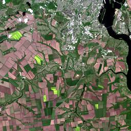
Natural view:
curl --location --request GET 'https://api-connect.eos.com/api/render/S2/36/U/XU/2016/5/2/0/B04,B03,B02/10/611/354' \
--header 'x-api-key: <your_api_key>'
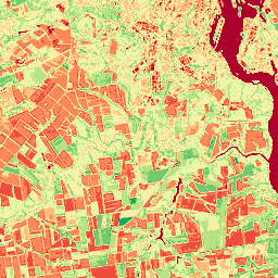
NDVI:
curl --location --request GET 'https://api-connect.eos.com/api/render/S2/36/U/XU/2016/5/2/0/NDVI/10/611/354' \
--header 'x-api-key: <your_api_key>'