Soil Moisture
About soil moisture solution
Satellite-based soil moisture monitoring relies on remote sensing technology, which involves measuring the reflection of microwave radiation emitted by the Earth's surface and mathematical algorithms to interpret the measurements into a clear figures
📡 The sensors on the satellite detect the microwave radiation reflected from the Earth's surface, and this information is then used to calculate soil moisture content. We use NASA's Soil Moisture Active Passive (SMAP) mission, namely the L1B_TB and L2_SM_P_E products. This satellite provides medium-resolution data (9x9km) on soil moisture content and ensures the global coverage
⚙️ We post-process the raw satellite data with an algorithm developed by the EOSDA in-house science team, which, in particular, takes into account soil maps (namely, the content of clay in the soil), which significantly improves the spatial resolution of the data to 250x250m
📈 Data on Soil Moisture is available from 2015 (to be more precise, from April 2015) until now and is regularly updated under the satellite operating schedule
💧 Surface and root zone volumetric moisture content are available in API. Volumetric soil moisture is the ratio of the volume of water to the volume of the entire soil.
Satellite-based soil moisture monitoring provides a number of benefits over ground-based measurements:
🌍 Firstly, it covers a much larger area than ground-based measurements, allowing for a more comprehensive view of soil moisture content.
🕛 Secondly, it provides measurements in near real-time, allowing for immediate action to be taken in response to changing soil moisture levels.
🏔️ Finally, it can provide data over remote or inaccessible areas, where ground-based measurements may be difficult or impossible to obtain.
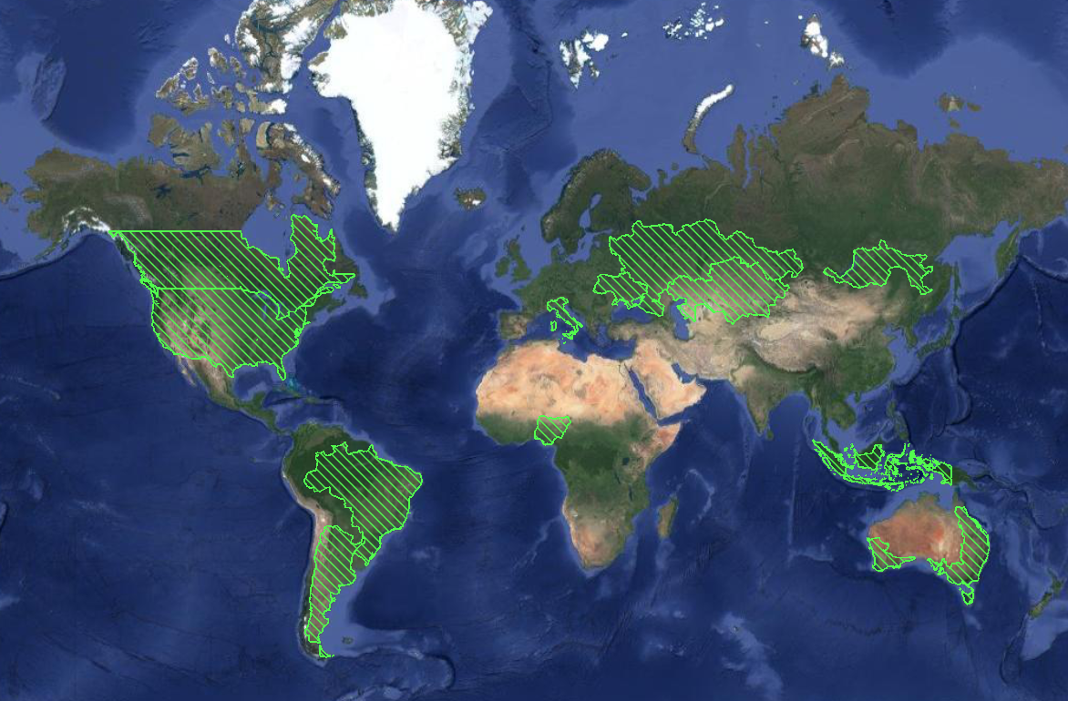
Coverage area: Argentina, Australia, Brazil, Canada, Russia, Ukraine, Kazakhstan, Nigeria, USA, Indonesia
If your specific location is not within our coverage area, you will receive an empty response when checking the task status. If you're interested in obtaining soil moisture data for your country, please don't hesitate to contact our sales team for a tailored solution

Data is available: from 2015
Resolution: 250x250m
Satellite revisit time (data update frequency): 2-3 days
Example - Get soil moisture data
Step 1: Create task for soil-moisture caclulating with POST request
curl --location 'https://api-connect.eos.com/api/gdw/api?api_key=<api_key>' \
--header 'Content-Type: text/plain' \
--data '{
"type":"mt_stats",
"params": {
    "bm_type":"soilmoisture",
    "date_start":"2023-06-01",
    "date_end":"2023-07-01",
    "geometry":
        {
        "coordinates": [
                          [
                              [-86.86718,41.317464],
                              [-86.86718,41.331596],
                              [-86.862631,41.331596],
                              [-86.862631,41.317464],
                              [-86.86718,41.317464]
                            ]
                        ],
        "type":"Polygon"
        },
    "reference":"ref_20200924-00-00",
    "sensors":["soilmoisture"],
    "limit":10
    }
}'
Example of response:
{
    "status": "created",
    "task_id": "1158865d-fd7f-4952-a7c1-a949e928d427",
    "req_id": "22075a17-ce81-4b79-be3e-f11b3d8cf852",
    "task_timeout": 345600
}
Step 2: Receive the result of calculation with GET request and use task_id from previous step
curl --location 'https://api-connect.eos.com/api/gdw/api/<task_id>?api_key=<api_key>'
Example of response:
average = Surface: 7cm
ctime_10 = Root zone: 70cm
{
    "errors": [],
    "result": [
        {
            "scene_id": "sm_250m_20230601_44503_usa",
            "view_id": "soilmoisture/sm_250m_20230601_44503_usa",
            "date": "2023-06-01",
            "cloud": null,
            "notes": [],
            "q1": 20.450000000000003,
            "q3": 20.900000000000002,
            "max": 21.0,
            "min": 20.1,
            "p10": 20.230000000000004,
            "p90": 21.0,
            "std": 0.2972092416687835,
            "median": 20.8,
            "average": 20.700000000000003,
            "variance": 0.8833333333333334,
            "ctime_10": 20.700000000000003
        },
      <...>
        {
            "scene_id": "sm_250m_20230630_44927_usa",
            "view_id": "soilmoisture/sm_250m_20230630_44927_usa",
            "date": "2023-06-30",
            "cloud": null,
            "notes": [],
            "min": 24.1,
            "max": 24.8,
            "average": 24.504166666666666,
            "std": 0.2009957849198723,
            "variance": 0.40399305555555565,
            "q1": 24.375,
            "q3": 24.625,
            "median": 24.6,
            "p10": 24.16,
            "p90": 24.700000000000003,
            "ctime_10": 20.664351791362535
        }
    ]
}