Terrain tile API
The API serves raster tiles of Terrain Tiles dataset - basemap digital elevation model (DEM) of the world in a raster tile format.
For more information on Terrain Tiles please refer to: https://mapzen.com/documentation/terrain-tiles/
| Parameter | Description |
|---|---|
| format | (optional) tile format [hillshade, geotiff, slope]. Default : hillshade |
| FILTERING | (optional) bool parameter, apply artifact removing (filtering) to tile? Default : FALSE |
| COLORMAP | (optional) name of colormap to be applied for slope. Default : terrain |
| MIN_SLOPE | (optional) min slope to be shown. Default : 0 |
| SLOPE_RANGE | (optional) slope range for map visualization and legend. Default : (0.0,90.0) |
| AZIMUTH | (optional, valid when format=hillshade) The azimuth is the angular direction of the sun, measured from north in clockwise degrees from 0 to 360. An azimuth of 90 degrees is east. The default azimuth is 315 degrees (NW). Visualization: https://www.youtube.com/watch?v=Vf0mAmxLU4M |
| ALTITUDE | (optional, valid when format=hillshade) The altitude is the slope or angle of the illumination source above the horizon. The units are in degrees, from 0 (on the horizon) to 90 (overhead). The default is 45 degrees. Visualization: https://www.youtube.com/watch?v=im84wGILI7I |
| THRESHOLDS | (optional, valid when format=hillshade) The value thresholds for coloring the terrain. |
| COLORS | (optional, valid when format=hillshade) The hex color values linked to the corresponding ranges, which are derived by given THRESHOLDS. |
Representation of DEM data
Various techniques can be used to visualize terrain data.
curl 'https://api-connect.eos.com/api/render/terrain/11/328/794?api_key=<your api key>'
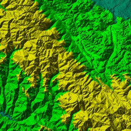
Hillshade
Shaded relief, or hill-shading, shows the shape of the terrain in a realistic fashion by showing how the three-dimensional surface would be illuminated from a point light source. For details, see: https://en.wikipedia.org/wiki/Terrain_cartography#Shaded_relief
GeoTIFF
Tiles in GeoTIFF format, with spatial reference. Default dimensions - 256 x 256 pixels. Default projection - EPSG:3857 (Pseudo-Mercator, Web Mercator).
Default representation
https://api-connect.eos.com/api/render/terrain/11/328/794?format=geotiff&api_key=<your_api_key>
Outliers filtering
https://api-connect.eos.com/api/render/terrain/11/328/794?format=geotiff&FILTERING=TRUE&api_key=<your_api_key>
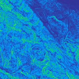
Slope
Slope is the measure of steepness or the degree of inclination of a feature relative to the horizontal plane. Wiki: https://en.wikipedia.org/wiki/Grade_%28slope%29
Default slope visualization
https://api-connect.eos.com/api/render/terrain/11/328/794?format=slope&api_key=<your_api_key>
Slope visualization with a custom palette
https://api-connect.eos.com/api/render/terrain/11/328/794?format=slope&COLORMAP=OrRd_r&api_key=<your_api_key>

Slope range correction
When a minimum and maximum values of slope are known in advance they can be set using SLOPE_RANGE query to enhance local representation.
https://api-connect.eos.com/api/render/terrain/11/328/794?format=slope&COLORMAP=Spectral&SLOPE_RANGE=0%2C70&api_key=<your_api_key>
HTTP Request
GET https://api-connect.eos.com/api/render/terrain/<z>/<x>/<y>?api_key=<your api key>
Example:
https://api-connect.eos.com/api/render/terrain/11/328/794?api_key=<your_api_key>
Elevation point value
Get elevation value in a given point.
curl -i 'https://api-connect.eos.com/api/render/terrain/point/<lat>/<lon>?api_key=<your_api_key>'
The above commands returns the following JSON with results
{"index_value": 1198.758544921875}
HTTP Request
GET https://api-connect.eos.com/api/render/terrain/point/<lat>/<lon>?api_key=<your_api_key>
Parameters
| Parameter | Value | Description |
|---|---|---|
| lat | 35.947344068 | Latitude geographic coordinate that specifies the north–south position of a point on the Earth’s surface |
| lon | 121.345009409 | Longitude is a geographic coordinate that specifies the east-west position of a point on the Earth’s surface. It is an angular measurement |
Query parameters
| Parameter | Value | Description |
|---|---|---|
| api_key | (Required) Apikey retrieved from developer portal |