Download visual
Fetch an 8-bit image with bands in EPSG:3857, available in formats such as "jpeg," "tiff," and "png"
HTTP Request
curl --location --request POST 'https://api-connect.eos.com/api/gdw/api?api_key=<your_api_key>' \
--header 'Content-Type: application/json' \
--data-raw '{
    "type": "jpeg",
    "params": {
            "view_id": "view_id",
            "bm_type": "bm_type",
            "geometry":{
                       "type": "Polygon",
                       "coordinates": [[
                                         [lon,lat],
                                         [lon,lat],
                                         .........,
                                         [lon,lat]
                                      ]]
                       },
        "px_size": number,
        "format":"tiff",
        "colormap": "colormap_id",
        "reference": "ref_datetime"
    }
}'
Request Parameters
| Parameter | Value | Description |
|---|---|---|
| api_key | <your api key> | (Required) Apikey retrieved from developer portal |
| Request Body Parameter | Description |
|---|---|
| type | (required) Operation name. Value is ‘jpeg’. |
| params | (required) Request parameters. |
| params.view_id | (required) View id of the scene returned by the Search API, see Search API. Example values: “L8/LC80110312016028LGN00”, “S2/19/T/CG/2017/7/9/0”, “MODIS/12/04/2017204/2017213034223” etc |
| params.geometry | (required) A GeoJSON representation of a geometry describing the AOI. Supported geometry types: “Polygon”. |
| params.bm_type | (required) Band combination to visualize. Example: “(B5-B4)/(B5+B4),(B3-B5)/(B3+B5),(B3-B6)/(B3+B6)”, “B5-1” etc. For available band combinations please refer to Name Aliases and Supported Datasets |
| params.name_alias | (optional) User name of the band combination to be used in output file name. |
| params.resample | (optional) Interpolation type to use with WMS. Valid values: “near”, “bilinear”, “cubic”, “cubicspline”, “lanczos”, “average”, “mode”, “max”, “min”, “med”, “q1”, “q3”. Default is “cubic”. |
| params.colormap | (optional) Colorize bandmath result with the specified colormap. For avaliable palettes see Colorization and example colormap |
| params.levels | (optional) An option to use with COLORMAP; rescale bandmath levels to the specified values. Default: -0.5,0.5 |
| params.colors_limit | (optional) An option to use with COLORMAP, used for colormap discretization. |
| params.calibrate | (optional) Convert DN to ToA reflectance if 1. Valid values: 0, 1. Default: 0 (calibration disabled). |
| params.px_size | (required) Output raster pixel size in meters. |
| params.size | (optional) Output image dimensions setting from LV. Used for logging purpose only. Valid values: “S”, “M”, “L”, “XL”. Default: null. |
| params.georeference | (optional) Return georeferenced image if provided. Valid values: “world”, “kmz”, “tiff”. If “world”: return an image (.jpeg) and a world file (.jpegw) in a zip archive; if “kmz” return “kmz”; if “tiff” return geotiff; else return an image (.jpeg). Default: null. |
| params.format | (optional) Image format. Valid values: “jpeg”, “tiff”, “png”. Default: “jpeg” |
| params.pansharpening | (optional) Apply pansharpening if True. |
| params.reference | (required) Unique id to assign to the request |
| params.colors | (optional) List of colors to use with range colorization. Thresholds are set in params.thresholds. For more info on range colorization see Range colorization |
| params.thresholds | (optional) List of thresholds to use with range colorization. Colors are set in params.colors.For more info on range colorization see Range colorization |
info
Image format. Valid values: “jpeg”, “tiff”, “png”. Default: “jpeg”
HTTP Response
The above commands returns the following JSON with task status
{
    "status": "status",
    "task_id": "task_id",
    "req_id": "req_id",
    "task_timeout": task_timeout
}
After that, you need to send a request for checking task status using task_id
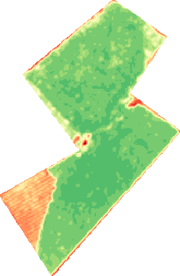
Example: Download image of the NDVI from Sentinel2 from the AOI
Step 1: Create task for index caclulating with POST request
curl --location --request POST 'https://api-connect.eos.com/api/gdw/api' \
--data '{
    "type": "jpeg",
    "params": {
            "view_id": "S2/13/R/EL/2023/7/19/0",
            "bm_type": "NDVI",
            "geometry":{"type": "Polygon",
                    "coordinates": [
                        [
                            [-104.87931347024973, 27.166227117387663],
                            [-104.87190853064376,27.17371136921598],
                            [-104.87486446023671,27.175686643908065],
                            [-104.87271173924485,27.178599422270565],
                            [-104.87575466983847,27.180525385046096],
                            [-104.88103048496039,27.176643443128853],
                            [-104.87771956045358,27.172771682872458],
                            [-104.88236756436531,27.17042134807906],
                            [-104.87931347024973,27.166227117387663]
                            ]
                        ]
                      },
        "px_size": 4,
        "format":"png",
         "colormap": "a9bc6eceeef2a13bb88a7f641dca3aa0",
        "levels": "-1.0,1.0",
        "reference": "ref_datetime",
        "calibrate": 1
    }
}'
Step 2: Receive the result of calculation with GET request and use task_id from previous step
curl --location --request GET 'https://api-connect.eos.com/api/gdw/api/5144aaff-f442-4b18-b20f-7c239ac15a3f' \
--header 'x-api-key: <your_api_key>'
Custom colormap
You can create custom colormap with Colormap endpoint